CAVEAT: I have done many bushwhacks, including Apparition Falls, Chak Chak Falls, multiple visits to Family Falls, Lindsey Creek Falls, Middle and Upper Bridal Veil Falls, Sorensen Creek Falls, Linton Creek, and others that I have probably forgotten about. Devil's Staircase was BY FAR the most difficult -- in fact, it might have been more difficult than all of my previous bushwhacks combined! During my first attempt, there were many moments which prompted me to consider my mortality. It is even more difficult than the Oregon Field Guide episode conveys. There is a reason for the ominous warning sign near the beginning of the boot path. This is NOT FOR EVERYONE. Accordingly, I am not going to post a GPS track, or any directions. even with a GPS track in hand and being accompanied by someone who had already made it to the waterfall, there is still an overwhelming probability that you will get lost.It took two attempts, but I finally made it to the fabled Devil's Staircase in the Oregon Coast Range. (Background information on the area can be found
here and
here.)
My friend Joey had visited last year, so I pestered him to take me. He finally acquiesced, so two weeks ago we made the long drive to the "trailhead" two hours southwest of Eugene. Most of the drive is on paved roads, but the last few miles are on a gravel road which turns into a country lane which Nature is threatening to reclaim. We made it in a normal clearance passenger car, but had to go very slowly to avoid bottoming out.
The trek is approximately 3.5 miles one-way. That doesn't sound like much, but it is definitely not for the faint of heart. Within 100 yards of the start of the boot path, visitors are greeted by this ominous sign which instantly reminded me of the infamous "
I'd Turn Back If I Were You" sign from "The Wizard of Oz".

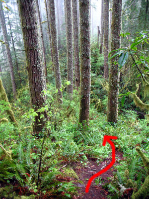
Then the fun really begins! Although the hike roughly follows a ridge line, it is hardly flat. It involves dropping steeply down to a saddle, then climbing just as steeply to the next ridge top, then repeating this half a dozen times before making the final plunge down to Wasson Creek. Although these photos cannot fully convey the steepness, here are several examples:

The red arrow indicates the boot path heading down this steep slope. See how quickly it disappears? That's not an optical illusion. The boot path seemed to fade in and out before my disbelieving eyes. There were often animal paths which looked more promising than the boot path, until they ended at a vertical slope where only sure-footed deer could continue.
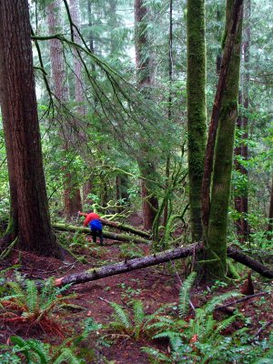
In this photo, Joey prepares to hop over more blown-down trees while skidding down another steep slope.

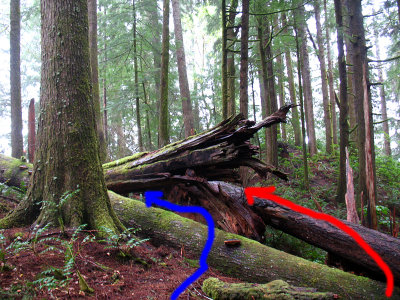
The next photo is a representative example of the obstacles on this trek. The red arrow shows the first option, which involves tiptoeing carefully along a slippery fallen tree. The blue arrow shows the second option, which requires shimmying under no less than three fallen trees.

I stopped counting after the first hundred blown-down trees.
Even though Joey had successfully made the trek once before, it is disturbingly easy to lose the "trail". Early on, we took what appeared to be a promising route, and ended up scrambling 800+ vertical feet down to creek level and thrashing through a salmonberry jungle. I have been on many bushwhacks and I knew this was going to be difficult, but I had not expected it to be
IMPOSSIBLE. There were more than a few moments when I thought I wasn't going to make it out alive! Many hours later, we finally made it back up the slope to the boot path and headed back to the car, utterly defeated. I was bleeding in a dozen places from the salmonberry and huckleberry thorns, and my shins were completely black and blue for several days afterwards.
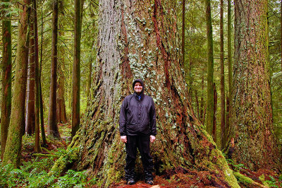
Our luck was much better the second time. First, the weather conditions were certainly better in terms of water photography... there was a 100% chance of rain, as opposed to the bright sunshine on the day of our previous failed attempt. We began the trek at 11:30 am in a steady rain, which lasted for the entire day. We passed the warning sign, noted where we lost the trail during our first attempt, and continue on to a grove of huge trees. We saw dozens/hundreds of huge douglas fir, hemlock, and cedar trees looming high above us, including this one:

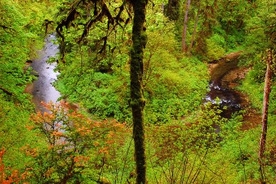
We lost the boot path a few times, but unlike our previous attempt we made the necessary corrections before going hopelessly off-course. Those corrections generally involved messy traverses of steep slopes, but we managed to avoid the salmonberry jungles that had bedeviled us the first time. After three and a half hours, we came upon this vantage point of Wasson Creek far below us:

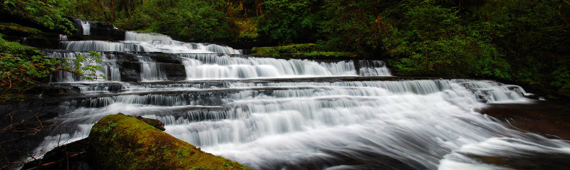
We knew that Devil's Staircase was close, so we eagerly began scrambling down the slope to the creek. Perhaps we were a bit too eager, because we didn't bother following the boot path and ended up far downstream. Once again we had to climb halfway back up the slope so that we could work our way upstream. But all of the sweat and toil was worthwhile when we finally saw it:

I was very pleasantly surprised, because I had never seen any photos where the waterfall was more than a trickle. I also shot this video.
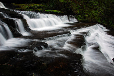
Here is a side view:

I could have stayed there all day exploring different vantage points. But common sense dictated that we leave after 90 minutes so that we would not bushwhack out in the dark. We had brought our head lamps, but they would provide limited assistance for the hazards of this particular trek. Up the ridge we went. Just before leaving the waterfall, I somehow managed to fill my boots with water. Every step on the return trip was a soggy sloshy mess.
During rainy conditions, I generally tend to drink less water than usual. That bit me halfway back to the trailhead... a burning cramp in my left thigh left me incapacitated for 10 minutes. When it finally diminished enough for me to continue, I tried to compensate by pushing off on my right leg during ascents. Sure enough, after several minutes of that, I had to stop again because of another cramp in my right thigh. As I waited for the pain to subside, I pondered the cruel symmetry and cursed myself for not having stayed hydrated. Fortunately, the cramps remained at bay until very close to the trailhead. As I felt the pain creeping back into both thighs, I gritted my teeth and forced myself to keep climbing. We made it back to the car moments before sunset... soaked, exhausted, but triumphant. 4 hours in, 3 hours out. Average speed: well under one mile per hour.